Discover the many highlights of Colombia, from rolling coffee hills to dazzling coastlines. Read more below about our favourite places and things to discover during a trip to this colourful country. When you're ready to plan your own adventure, packed with Colombia highlights, you can choose from our suggested itineraries and combine with our responsible experiences for a memorable holiday with a positive impact to boot.
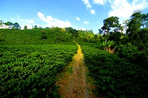
The Coffee Zone is a geographical area that comprises of 3 Colombian departments: Las Caldas, Risaralda and Quindio. The cities of Manizales, Pereira and Armenia. The departments have many things in common including a deep rooted coffee culture, the pre-Colombian history that is more ingrained than the Spanish legacy, its beautiful landscapes the friendliness and hard-working nature of the people. Nevertheless, each has it particularities: Manzales stands out for its cultural life, museums and monuments, Armenia as the heart of the region and for being reconstructed after the earthquake of 1999 and Pereira due to its commercial activity, gastronomy and nightlife.
Most of the coffee production in Colombia is based here and for that reason the region is aptly named the Coffee Zone. The fertile valleys with their seemingly endless coffee plantations, traditional wooden houses with brightly colouored balconies come together to create the typical and vibrant landscape of this region.
The wax palms – the national tree – mark spectacular Cocora valle: other colours can be seen in the region, such as in orchids, heliconias; in birds such as humming birds parrots and butterflies, in the Parc Nacional de los Nevados which reaches altitudes surpassing 5000masl and the beautiful architecture of towns like Salento and Filandia. This region is also united by the beauty and warmth of its people.
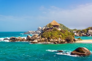
Tyrona national park is located on the Colombian Atlantic coast, a few km from Santa Marta. The park's boundaries extend from just beyond the bay of Teganga to where the Piedras River opens out into the sea. The national park covers an area of 15000 hectares, 75% of which are of land and the remaining are marine. The climate here oscillates between temperate and hot, with an average temperature of 25-30 degrees Celcuis. One of the main entries to the park is found at el Zaino, 34km from Santa Marta, from here one can gain access to the bay's natural beaches, coral reefs, mangroves, mountains and exuberant vegetation found within. Many types of animal inhabit the park, including more than 100 mammal species, 200 birds and numerous reptiles that makes up part of the Sierra Nevada de Santa Marta, a mountain range separate from the Andes that makes for a unique ecosystem that rise up from sea level where there are beaches of fine white sand before passing through tropical forests to snow-capped altitudes of 5770 masl.
In Tyrona national park there are various archaeological sites that prove the existance of ancient cultures, such as the Tyrona city of Chairman or Pueblito, where a community of at least 400 indigenous people thrived in the pre-Colombian period. Today there are still points of interest sacred to the Koguis, Arhuacos and Arsarios people. These tribes are all descented from the ancient Tyrona people who were one fo the most advanced pre-Colmbian tribes to have lived over the centuries in the Sierra Nevada.
From the bay of Cañaveral, a 3 hour hike over a stone pathway leads to Pueblito one of the most well-established Tyrona developments. The beaches of Arrecifes, La Piscina, Cabo de San Juan del Guia and Castilletes are within reach from Cañaveral as well. These beaches are all very distinct, some with still inviting waters, others with turbulent surf and thick with vegetation but all making the visitor feel as if he or she has been transported to another world, one of savage yet paradisical scenery. In the park itself there are many opportunities to enjoy such activities as mini-treks, snorkeling, bird-watching, kayaking biking or just contemplating nature.
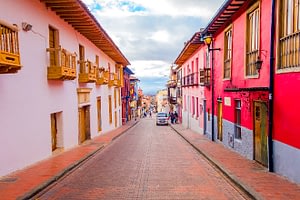
Bogota is the sprawling, chaotic and captivating capital city of Colombia. With around 8 million inhabitants, it's the most important political and financial city in the country. It is situated in the geographical centre of Colombia at an altitude of 2640 masl. on a plateau known as the Sabana de Bogata on the west of the Andes mountains. Bogota's privileged location means that it is blessed with a year-round Spring-like climate where the flowers are always blooming. Bogota has a diverse variety of “barrios” or neighbourhoods: the tall modern buildings are located in an area called Centro Internacional and just behind it you find the bohemian Macarena district, where the Plaza de Torros is located. The historic centre is called the Candelaria and it's the where the colonial city was created. It also holds the seat of government snd Congress. To the north you can find the barrios of La Merced and Teusaquillo which stand out for their distinctly British architecture. The city was founded on August 6th 1538 and was given the name of Santa Fe by the conquistador Gonzalo Jimenez de Quesada, who arrived in these lands in sserach of gold and who defeasted the chibcha indigenous people in Bacata.
Bogota is today a modern city with a bubbling cultural scene and vibrant social aspect. Picturesque with an important architectural heritage, the most impressive collection of pre-Colombian art in the world, unrivalled urban graffiti and fantastic museums. The poverty that lives alongside such wealth form contrasts that make this a fascinating city.
Founded in 1533 on an original indigenous Carib settlement, the Spanish conquistador Don Pedro de Heredia founded the city of Cartagena de Poniente to distinguish it from Cartegena de Levante in Spain. Later the city became known as Cartagena de Indias, a name which remained until the end of the colonial era and the beginning of the Republic. This colonial city rapidly became the gem in the Spanish crown's territories. It was fortified between 14th and 19th centuries and in order to protect it from the continual attacks by foreign buccaneers and pirates and when these fortification were completed it was the most impenetrable and largest in the Americas.
Cartgena was the first province of the Nuevo Reino de Granada which gained it's independence from Spain on 11 November 1811 and the city still boasts architectural treasures in its civil, domestic, religious, military and governmental constructions.
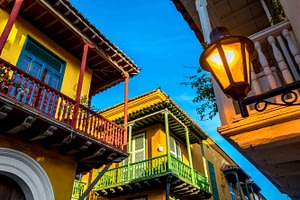
Just walking through its narrow but remarkable streets there is enough to understand why Cartagena is a UNESCO World Heritage site. Perhaps the real joy of Cartagena is exploring its streets on foot, an experience that awakes all 5 senses with a ryhthm of cumbia and mapale, with the flavours of the Caribbean , with blend of the natural world against the variations in architecture, all the while buffeted by the Caribbean breeze, making this city an incredibly romantic destination. The cultural wealth that Cartagena enjoys is a result of the mix in backgrounds of the city's inhabitants and it architectural beauty. And the warm afternoon winds make Cartagena one of the Caribbean's most fascinating cities.
The town of Villa de Leyva, located 207 km from Bogotá at an altitude of 2,140m, was founded in 1572 by Hernán Suárez de Villalobos who named it after Andrés Días Venero de Leyva, the first president of Nueva Granada. Before the arrival of the Spanish, the area was inhabited by the Muiscas, a Chibcha-speaking people who built their main astronomical observatory at the site of the current town.
Villa de Leyva is one of the most beautiful towns in the area and is ideally explored on foot. It was declared a national monument in 1954 and has remained free of modern constructions. It is as if one can still breathe in the atmosphere of colonial times when visiting the expansive Plaza Mayor which at 14,000 m2 is the country’s largest. This special atmosphere does not end at the Plaza as it courses through the surrounding cobblestone streets; the Cathedral; the house of Antonio Nariño, home to the Independence hero; the home of Antonio Ricaurte, who fought under Bolívar and is known for his heroic sacrifice during the battle of San Mateo; the House of Congress where, on October 4th 1812, the first Congress of the United Provinces of Nueva Granada took place; the Colonial Art Museum; The Monasterio and Convento del Carmen.
Nearby Villa de Leyva also there are many towns, each with its particular curiosity such as Ràquira which in the Chibcha language means “city of the pots” and therefore is known as the Colombian town that specializes in fine handmade ceramics; Sutamarchàn, famous for its gastronomy, especially longaniza and morcilla spicy sausages and the Tomatina Festival, which comes from a Spanish tradition; and Tinjacà known for its tagua (the seed of palm) handicrafts.
Medellín, the capital of the department of Antioquia, is located deep in the fertile and mountainous Aburra valley in the central Andean highlands. It is at an altitude of 1538masl which gives this city an eternal springtime with an average climate of 20°C. In 1541, roughly, the Spanish named this valley as San Bartolomé. Later, on 1616, under the orders of Francisco Herrera Campuzano, the land where today the barrio of El Poblado is located, was renamed San Lorenzo de Aburrá. This name, Aburrá, stems from a translation from the Aburraes and Yamesíes indigenous tribes which most likely refers to the embroidery in the cotton and textile work that these pre-hispanic people used to do, prior to the arrival of the colonial invaders. Then, on November 2, 1675, the Villa de Nuestra Señora de la Candelaria de Medellín was founded.
Originally Medellín was a modest, humble town which is evident from its colonial buildings that are far from sumptuous, and whose origins date back to the coffee boom of the 20th Century. Once coffee fever had taken hold of Medellín, the city’s economic development began in earnest and the Federación Nacional de Cafeteros de Colombia was created on June 27, 1927.
From here on, the city was transformed thanks to the resourcefulness and hardworking nature of its citizens, the Paisas, as thepeople of Medellín are known. While the city initially flourished, things stagnated somewhat in the 1980s at the height of the narco-trafficking period leaded by Pablo Escobar. The name Medellín became a by-word for drugs, violence and the narco-mafia. After a disastrous era of severe violence the city has, for the most part, turned the page on these dark days and the population, showing its strength, has made clear its desire to associate the city international image with its real values: the thriving cultural life in the fields of journalism, literature, urban and fashion design, as well as the artwork and sculptures of the globally renowned artist, Fernando Botero. Furthermore, Medellín has become a bustling city of industry and commerce, especially textile manufacturing and exported cut flowers, which represent the best example of the whole country social transformation.
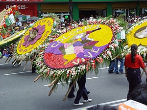
The city is well worth visiting during the annual Flower Festival, held over two weeks during July and August. The key events and perhaps the most interesting are the exhibitions of orchids, birds and flowers and the most representative parade, that of the Silleteros. During this procession the participants carry floral displays weighing up to 60 kilos each. The name “silletero” comes from the tradition that these farmers used to, and indeed still do practice, of carrying their children on chairs. However, this tradition has become a cultural phenomenon and rather than carrying children, the farmers transport these heavy floral arrangements instead.
Words used to describe the Amazon can seldom to do any justice to this remarkable place that stays imprinted on the memory. The incredible size of the Amazon River, an irrepressible source of life, and the crisscross pattern of the smaller tributaries that splay out through the jungle leave an indelible impression. The Amazon is the second longest river in the world after the Nile River. His water source receives the runoff of hundreds of rivers and streams that extend all the way from the Peruvian Andes north of the city of Arequipa representing the source of the 20% of fresh water in the planet. It runs for 6,275 kilometres from the Andes Mountains to Pará in Brazil, passing through the main cities as Iquitos (Peru), Leticia (Colombia) and Manaus (Brazil).
The city of Leticia is located on one of the banks of the Amazon River in the heart of the most resplendent and exuberant forest on earth. An imaginary line is drawn here creating a frontier between three countries: Colombia, Brazil and Peru. Leticia is the capital of the Colombian Amazon Department and the arrival port for flights from Bogotá, boats from Iquitos (Peru) and Manaus (Brazil) and the departure point to explore the area. It was founded in 1867 as San Antonio and was originally a Peruvian town until 1922 when it was ceded to Colombia and renamed becoming this country’s access to the “Green Lung”. The expeditions launched to explore the jungle towards Manaus and Iquitos all departed from Leticia. It rains frequently in the Amazon but the wettest season is between February and April.
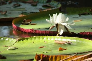
The waters of rivers reach their highest levels from February until the start of June thus making it the best time for bird-watching, piranha fishing, pirarucu (sport fishing) and seeing the Victoria Regia – an enormous aquatic lily plant with large purple flowers, white petals and floating leaves that can reach up to two meters in diameter. In this season, it is a little bit easier to see forest animals and reach most places by boat. The driest months are in July and August. Rivers are at the lowest water levels from August to November, when many beaches are created by the retreating waters at the riverbanks, and this is when the river turtles lay their eggs. During this season, it will be more comfortable to explore the area as paths will be less muddy and there will be fewer mosquitos, but many places would have to be reached by land, therefore requiring longer walks.
Numerous indigenous communities live in these areas including the Huitotos, Yaguas and Ticunas all of whom have protected their cultures and traditions passing down their practices from generation to generation such as their knowledge of medicinal plants, magic, ceremonies and aptitudes for survival in the jungle. 75 km and 2hrs by boat from Leticia in the upper Amazon River is the town of Puerto Nariño which is considered the cradle of life of the Amazon for its natural and cultural setting of peace and harmony. This community is located on the banks of the river Loretoyaco where motor vehicles are outlawed and the only way of getting around is on foot. Puerto Nariño probably shows one of the purest and clearest examples of community’s concept, where people are deeply involved with the environmental issues, the preservation of sea fauna and green-life, living free of smog and pollution. The Tarapoto Lake is nearby and its waters are like a natural aquarium as it is home to grey and pink river dolphins.

